
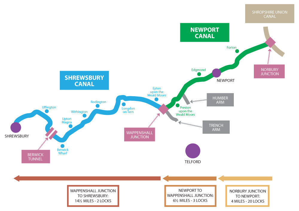
The route of the canal to Shrewsbury begins at Norbury Junction, where the Newport Branch leaves the main line of the Birmingham & Liverpool Junction Canal (now better known as the Shropshire Union). The community which has grown up here owes its existence totally to the canal. In its heyday it was an important maintenance depot for a large mileage of canals with over one hundred men based there.
From the Junction Bridge, numbered 1 on the route to Shrewsbury, the short stretch of the canal to the first lock is used as moorings. This lock, the first of the “Seventeen Steps” flight, is now used as a dry-dock.
Many of the locks in the flight have been buried whilst the remainder are deep within wood and scrub growth. Much of the very fine stonework of both the locks and bridges is in good condition although not surprisingly little remains of the wooden gates.
Near Forton is a most unusual aqueduct which carries both the canal and a road over the River Meese. Close by is the very fine Skew Bridge which derives its name from the angle at which the road crosses the canal. This remarkable combination illustrates the art of the stonemason and canal builder.
The Newport by-pass crosses the canal at Meretown and shortly after the one and a half miles of canal which remains fully in water through Newport begins. On this length can be seen a number of locks (capped with concrete but largely intact), the fine Summer House Bridge, a typical lock-side cottage at Fisher’s Lock and Newport Basin, once a busy wharf, of which one original building remains.
By Edgmond the canal has descended 23 locks from Norbury and the remainder of the route to Shrewsbury is virtually level. The canal passes through Preston-upon-the-Weald-Moors and then crosses the Duke’s Drive, although the fine aqueduct was sadly demolished in the 1960s. This was a smaller version of that on the Shropshire Union Main Line at Stretton familiar to many travelling the A5.
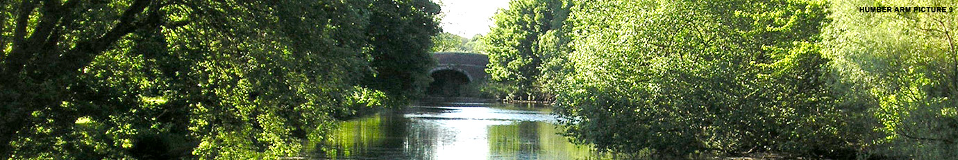
On this length the Humber Arm runs one mile to the south towards Donnington. Originally it was planned to run to Lilleshall and have seven locks.
At Wappenshall the Newport branch of Thomas Telford’s canal meets the earlier Shrewsbury Canal. The splendid bridge at the junction still clearly shows how it carried both a roadway and the towpath of the Shrewsbury Canal, the two being separated by a wall. A fine transhipment warehouse also survives.
Eyton is the site of the final two locks. These were widened from the original very narrow locks when the Newport branch was built and are unusual in that they have guillotine bottom gates rather than the usual mitre gates.
At Long Lane the bridge that originally carried the A442 over the canal has been by-passed and the road now crosses the canal almost at water level.
At Longdon-upon-Tern is the oldest surviving iron aqueduct in the world. The 62-yard long trough was cast at Ketley, to the design of Thomas Telford, using one inch thick plates and carried the canal over the River Tern. However, it was not planned this way and only came about when the original stone aqueduct was swept away in a flood on 12 February 1795, before it had ever been used. The cost of the iron aqueduct was £2000!
At Rodington the canal crosses the River Roden. Here was another notable brick aqueduct, which has sadly been destroyed, although nearby an aqueduct over an entry to a field survives.
The canal continues through Withington, Upton Forge, Berwick Wharf to Uffington. On this stretch of canal is Berwick Tunnel which is 970 yards long and was notable for the fact that it originally had a wooden towpath, although this was removed in 1819. Sadly this stretch has also been crossed at two points by the new A5.
From Uffington to Ditherington the canal has for many years been used as a public footpath and now features some nature pools. At Pimley the canal comes very close to the River Severn.
At Ditherington, the canal passes in front of the Maltings (the world’s oldest iron framed building), and from here to near the terminus the line of the canal can be followed on foot to the Canal Tavern. The observant will spot the sign for Factory Bridge set in to a wall opposite the Maltings. The terminal warehouse in Shrewsbury is now the Buttermarket night spot near the prison.
 The route of the canal to Shrewsbury begins at Norbury Junction, where the Newport Branch leaves the main line of the Birmingham & Liverpool Junction Canal (now better known as the Shropshire Union). The community which has grown up here owes its existence totally to the canal. In its heyday it was an important maintenance depot for a large mileage of canals with over one hundred men based there.
 Near Forton is a most unusual aqueduct which carries both the canal and a road over the River Meese. Close by is the very fine Skew Bridge which derives its name from the angle at which the road crosses the canal. This remarkable combination illustrates the art of the stonemason and canal builder.
 At Wappenshall the Newport branch of Thomas Telford’s canal meets the earlier Shrewsbury Canal. The splendid bridge at the junction still clearly shows how it carried both a roadway and the towpath of the Shrewsbury Canal, the two being separated by a wall. A fine transhipment warehouse also survives.
